Construction for the Magnolia Drive Trail began on Wednesday, May 8th June 5, 2024 on the section from Pontiac Drive to Diamond Street. (delayed due to the May 10 tornadoes)
The project includes:
● Roadway reconstruction.
● Moving the electric lines underground and upgrading water and sewer infrastructure
● Enclosing the storm water drainage
● Building a Multi-use path
● Adding a landscape buffer between the path and the roadway
● Adding a traffic light at the intersection of Jim Lee Road and Magnolia Drive.
The project is estimated to take 18 months; Magnolia Drive will be closed from Pontiac Drive to Diamond Street, inclusive, for the entire duration.
Leon County has designated a “local traffic only” zone which you can see on the map below in pink. Non-local traffic will be detoured to use Meridian/Monroe or Blair Stone Road, instead of Magnolia. To reduce the use of residential streets being used as shortcuts, barricades with “Road Closed to Through Traffic” signs will be in place at the intersections that border this zone: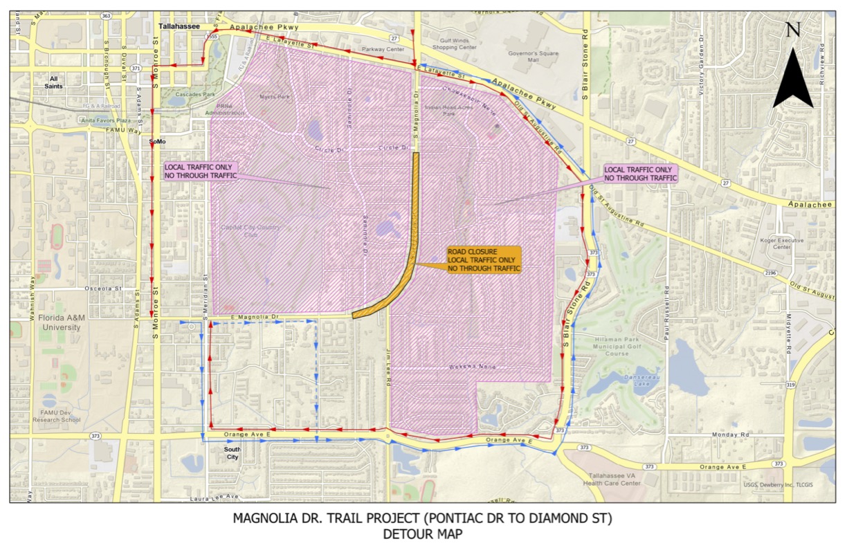
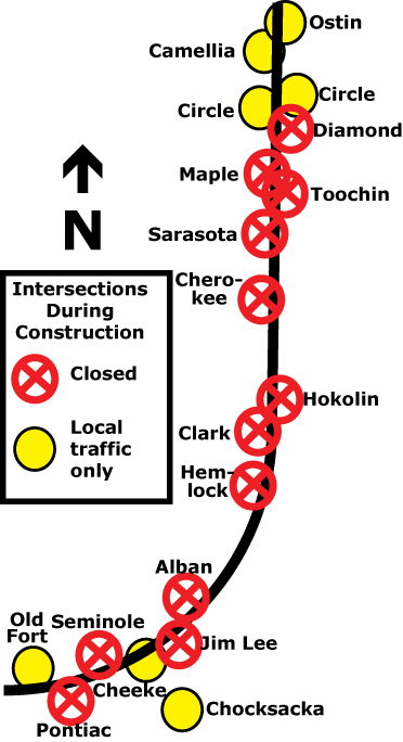
Streets that intersect with Magnolia will be closed to all traffic except those who live on Magnolia. The graphic shows the closed intersections for this project:
The roll-out of the street closure and detours will likely cause some confusion and frustration at first. The neighborhood association board plans to stay in close contact with Leon County to suggest any necessary changes to the management of traffic plan if improvements are needed along the way.
Please share your questions and concerns with us by emailing our neighborhood email address so that we can relay them to Leon County staff overseeing this project: email hidden; JavaScript is required
JUNE 2024 UPDATE
For the next several weeks, Magnolia will be fully closed only from Pontiac to Hemlock (where Magnolia starts to curve West, south of Hokolin).
Non-local traffic will still be detoured to Blair Stone and Monroe along Orange and Lafayette/St-Augustine, but our ability to turn right (heading North) on Magnolia from Hokolin, Toochin and Diamond will not be impaired for the time being.
Some improvements have been made to the signage and barricades on the Jim Lee end: the electronic sign now spells out to follow the detour along Orange, Lola/Eleanor/Mountbatten all have “closed to thru traffic signs”, and Chocksacka is barricaded (closed to all traffic). Cars can still come up Jim Lee and circumvent the signs but they will be met with three sets of “closed road” signs and have to turn around at Magnolia if they ignore all of them. The project manager explained that short of having police stationed on the road all day, they actually cannot even prevent drivers from driving on their work site.
At Lafayette and Magnolia, they will maintain the detour signs giving the choice of a right or left turn on Lafayette to South bound traffic (even though the road work doesn’t start until Hemlock). Without that, the number of non-residents turning on our streets and Woodland Drive streets from further down on Magnolia would increase. In other words, the signs on Orange and on Lafayette are working to deter some drivers.
We still expect an increase in traffic in the neighborhood but it will likely be more dispersed since drivers are not being funneled down any one street in particular.
As mentioned previously, this is a County project and control over traffic once on our neighborhood streets is beyond their purview. The City and TPD are responsible for addressing issues of speeding on residential streets and we are directing our request to them to implement measures to do so.
Please continue sharing your concerns with us by email at email hidden; JavaScript is required.
Archive of documents from the planning stage: